Mountain Tsunamis by Basanta Shrestha
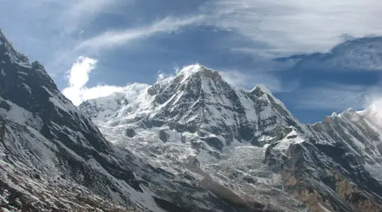
The glaciers of the Himalayas, stretching 4,000 kilometres from Afghanistan in the west to China and Myanmar in the east, are a source of life for hundreds of millions of people living in the mountainous region and its adjoining plains. The world’s loftiest mountain chain — its name is a combination of two Sanskrit words ‘hima’ (snow) and ‘alaya’ (abode) — boasts more than 30 peaks above 7,600 metres and has the largest concentration of glaciers outside the poles. Nature’s renewable storehouse of fresh water, they provide the headwaters for major river systems throughout Asia. Like other glaciers around the world, they also provide a unique medium for scientific exploration and for studies of the complex climate system.
Glaciers worldwide are retreating in the face of accelerating global warming, as human activities cause steadily increasing concentrations of greenhouse gases in the atmosphere: their melting is an important indicator of climate change. By one forecast, up to a quarter of the global mountain glacier mass could disappear by 2050, and up to half could be lost by 2100. Changes in temperature are more pronounced at higher altitudes, and several studies have revealed that the Himalayan glaciers have been melting at an unprecedented rate in recent decades.
This will cause major changes in freshwater flow regimes and thus have dramatic impacts on drinking water supply, biodiversity, hydropower, industry, agriculture and livelihoods. Important baseline information on the Himalayan glaciers has been documented by a study for the global change research programme by the International Centre on Integrated Mountain Development (ICIMOD) in partnership with UNEP and the Asia Pacific Network, and in close collaboration with national partner organisations. This identified some 15,000 glaciers covering a total area of 33,340 square kilometres in Bhutan, Nepal and Pakistan and selected river basins in China and India. Observations of individual glaciers indicate that, in some cases, rates of retreat have doubled since the early 1970s, though they vary from basin to basin. The release of studies on Bhutan and Nepal in 2001 significantly raised the global community’s awareness about what is taking place and the resulting impacts.
A long-term Chinese Academy of Sciences study ‘The Chinese Glacier Inventory’ reported a 5.5 per cent shrinkage in the volume of the country’s 46,928 glaciers over the last 24 years — equivalent to losing more than 3,000 square kilometres of ice. It predicted that, two-thirds would disappear by 2050, and almost all would be gone by 2100 if the climate continues to change at the present rate. Meanwhile an ICIMOD study found that the area of glaciers in the Poiqu basin of Tibet Autonomous Region had decreased by over 5 per cent between 1988 and 2000: in some cases they retreated by over 50 metres a year. Similarly, the Gangotri Glacier snout in the Indian Himalaya moved about two kilometres uphill between 1780 to 2001 and its retreat is continuing at an alarming rate. And in Bhutan, comparing 66 glaciers on a 1963 map with a 1993 satellite image revealed that they had shrunk by 8.1 per cent, with some small ones disappearing completely.
As glaciers retreat, lakes form behind their newly exposed terminal moraines. Most of the glacial lakes in the Himalayas have appeared within the last five decades. They can grow startlingly quickly: the Imja Tsho and Tsho Rolpa glacial lakes in Nepal are respectively expanding by about 41 metres and 66 metres a year. Such a rapid accumulation of water can lead to sudden breaching of their unstable natural dams and become Mountain Tsunamis. Huge amounts of water and debris are then released, in what are known as a Glacial Lake Outburst Floods (GLOFs).

Mountain tsunamis have already been reported in the region; in 1985, one from the Dig Tsho Lake in the Everest National Park in Nepal killed several people and destroyed trails, bridges, houses, arable land and a nearly completed hydropower plant. Future floods could have even more catastrophic effects, becoming ‘mountain tsunamis’ that put millions of people downstream at risk.
Monitoring Himalayan glaciers using conventional methods is difficult and challenging because of their inaccessibility, the high rugged terrain and the harsh climatic conditions. The size and remoteness of most mountain glaciers ensures that monitoring and assessing them relies heavily on satellite techniques. Concerted efforts are needed continuously to monitor glaciers, to mitigate the dangers from them, and to provide an early warning system of potential GLOFs. As GLOF disasters often cross boundaries, regional cooperation is needed to formulate a coordinated strategy to deal effectively both with them and with water management issues.
Himalayan glaciers are an inherent part of the region’s life support system and their retreat provides compelling evidence of the need to act urgently on the pressing issues of global climate change. It may be difficult to predict exactly how they will melt in future, but it is clear that it is time to get our act together to avoid the most damaging consequences. Immediate action is needed by the international community to safeguard the precious natural resources of this relatively unexplored — yet one of the most spectacular — regions of the world.
Source for Mountain Tsunamis: Basanta Shrestha, may 2007, OUR PLANET, The Magazine of UNEP.