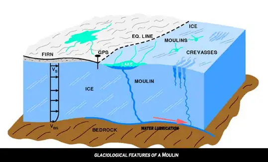
What Is a Moulin?
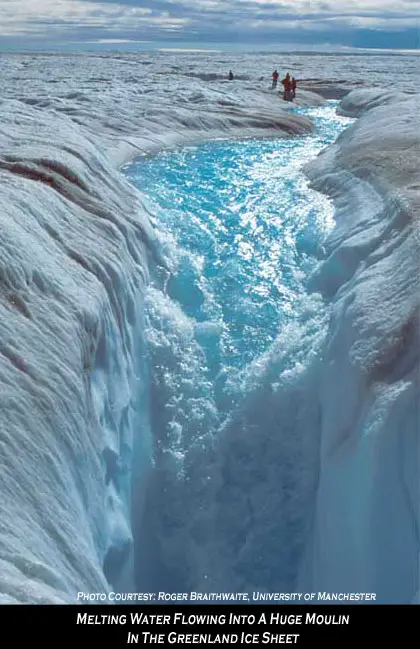
A moulin (French for “mill”) is a narrow, tubular chute, hole or crevasse worn in the ice by surface water, which carries water from the surface to the base far below. They can be up to 10 meters wide and are typically found at a flat area of a glacier in a region of transverse crevasses. These holes can go all the way to the bottom of the glacier and can be hundreds of meters deep, or may reach the depth of common crevasse formation (about 10-40m) where the stream flows englacially.
These holes are a part of a glacier’s internal “plumbing” system, to carry melt water out to wherever it may go. Water often exits the glacier at base level, but occasionally the lower end of a moulin may be exposed in the face of a glacier or at the edge of a stagnant block of ice.
Moulin Concerns
The cascading water through the ice pushes down on the glacier at the same time water seeps through cracks to the underside. In this way, water becomes a lubricating fluid at the base of the glacier, enhancing glacial motion and speeding disintegration of the ice sheet. The melting water encourages further ice loss and accelerates the glacier’s flow to the sea, where large chunks break off to form icebergs.
Decreasing sea ice at the Poles is deeply concerning scientists, as it has an important function in moderating the global energy balance. Sea ice has albedo of 0.8 which means it reflects 80% of the suns rays, but When the sea ice melts to form water the albedo is only 0.2. In other words, the highly reflective sea ice goes from absorbing 20% of the sun’s rays to absorbing 80%, creating a positive feedback for further warming.
Although building glaciers is very slow, taking thousands of years, once an ice sheet starts to collapse, its demise can be spectacularly rapid. Once large scale glacial collapse begins, it is impractical to stop and as more ice moves from glaciers on land into the ocean, it raises sea levels.
The Jakobshavn Glacier is Greenland’s fastest moving glacier and major contributor to the mass balance of the continental ice sheet. Starting in late 2000, following a period of slowing down in the mid 1990s, the glacier showed significant acceleration and nearly doubled its discharge of ice. Researchers found the glacier’s sudden speed-up also coincides with very rapid thinning, indicating loss of ice of up to 15 meters (49 feet) in thickness per year after 1997. Recent NASA funded research in the Antarctic Peninsula showed similar increases in glacier flow following the Larson B ice shelf break-up.
Video of Jakobshavn Glacier Calving from 2001 through 2006 – Since measurements of Jakobshavn Isbrae were first taken in 1850, the glacier gradually receded until about 1950, where it remained stable for the past 5 decades. However, from 1997 to 2006, the glacier has begun to recede again, this time almost doubling in speed. The finding is important for many reasons. As more ice moves from glaciers on land into the ocean, ocean sea levels raise. Jakobshavn Isbrae is Greenland’s largest outlet glacier, draining 6.5 percent of Greenland’s ice sheet area. The ice stream’s speed-up and near-doubling of ice flow from land into the ocean has increased the rate of sea level rise by about .06 millimeters (about .002 inches) per year, or roughly 4 percent of the 20th century rate of sea level increase. This animation shows the glacier’s flow in 2000, along with changes in the glacier’s calving front between 2001 and 2006.
Video Source: NASA/Goddard Space Flight Center Scientific Visualization Studio