Background
Measuring sea level has a long history, and people in the past linked the regular movements of the sea to the movements of the moon and sun. Of course there were also those that thought the tides were due to the powers of the Gods. Scientists now understand that neither the land nor the sea levels are permanent, and they are in a constant state of flux. There are vertical movements of the land associated with glacial changes and other tectonic processes. Changes in the mean sea level relate to changes in the volume of water in the oceans and to variations in the ocean currents.
Based on ocean temperature observations, the thermal expansion of seawater as it warms has contributed substantially to sea level rise in recent decades. Climate models are consistent with the ocean observations and indicate that thermal expansion is expected to continue to contribute to sea level rise over the next 100 years. Since deep ocean temperatures change only slowly, thermal expansion would continue for many centuries even if atmospheric concentrations of greenhouse gases were stabilised.
The basis for any scientific analysis of measuring sea level must be a long series of careful measurements. Any instantaneous measurement of sea level in a series may be considered the sum of three component parts: observed level mean sea level + tide + meteorological residuals
Each of these component parts is controlled by separate physical processes and the variations of each part are essentially independent of the variations in the other parts. Each of these components is defined below:
Tides are the periodic movements of the seas which have coherent amplitude and phase relationship to some periodic geophysical force. The dominant forcing is the variation in the gravitational field on the surface of the earth due to the regular movements of the earth-moon and earth-sun systems. These cause gravitational tides. There are also weak tides generated by periodic variations of atmospheric pressure and on-shore off-shore winds which are called meteorological tides.
Meteorological residuals are the non-tidal components which remain after removing the tides by analysis. They are irregular, as are the variations in the weather. Sometimes the term surge residual is used but more commonly surge is used to describe a particular event during which a very large non-tidal component is generated.
Mean sea level is the average level of the sea, and measuring sea level is usually based on hourly values taken over a period of at least a year. For geodetic purposes the mean level may be taken over several years.
Measuring Sea Level
A complication in measuring sea level, is that the sea-level does not rise by the same amount all over the globe due to the effects of the earth’s rotation, local coastline variations, changes in major ocean currents, vertical movements of the earth’s crust (up and down), and differences in tidal patterns and sea-water density.
Today, there are two primary points of measurement.
1. The first is the relative sea level (the height of the water relative to the land), measured using tide gauges. However, it becomes critical to know whether the land itself is moving before knowing whether the absolute height of the oceans is changing.
2. Satellite altimetry measures the distance between an Earth-orbiting satellite and the surface of the ocean. Knowing accurately the position of the satellite we can know the height of the ocean relative to the centre of the Earth.
 Measuring Sea Level – Tides
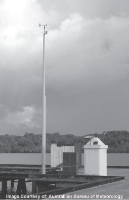
Over the past decade or so a network of high resolution monitoring stations has been established throughout the Pacific region to provide the scientific community with information on sea levels. Measuring sea level in this way is an initiative known as the Sea Level Fine Resolution Acoustic Measuring Equipment (SEAFRAME), with monitoring stations throughout the South Pacific. The one pictured on the left is in Manus Province of Papua New Guinea.
The SEAFRAME stations measure water levels; barometric pressure; and wind speed, direction, and gusts and air and water temperatures. All these measurements are needed to enhance the value of the relative sea level measurements and place them in context. El Nino can cause sea levels to change between 30 and 50cm and storm surges can make a difference of more than a metre. Conventional tide gauges had, until then, measured water levels to an accuracy of 1cm. This was not sensitive enough to measure small and gradual changes in just a few decades. Sea frame sensors can accurately measure to one millimetre.
These tide gauges are quite different to the older style float tide gauges, and are tied into the Continuous Global Positioning System.
CGPS Monitoring Stations – The Continuous Global Positioning System (CGPS) network monitors vertical movement in the earth’s crust, such as subsidence or tectonic shifts, at the SEAFRAME tide gauges and adjacent land. Sea level data can then be adjusted to compensate for the earth’s movement to within a millimetre, enabling the absolute sea level to be determined. Over the last century, global sea level change has typically been estimated from tide gauge measurements by long-term averaging.
Alternatively, satellite altimeter measurements can be combined with precisely known spacecraft orbits to provide an improved measurement of global sea level change.
Measuring Sea Level – Satellites
Since August 1992 the satellite altimeters have been measuring sea level on a global basis with unprecedented accuracy. The TOPEX/POSEIDON (T/P) satellite mission provided observations of sea level change from 1992 until 2005.
Jason-1, launched in late 2001 as the successor to T/P, continues this record by providing an estimate of global mean sea level every 10 days with an uncertainty of 3-4 mm. Although Jason-1 was designed to replace TOPEX/Poseidon, scientists took advantage of TOPEX/Poseidon’s unexpected longevity by placing the satellites in a tandem orbit.
During its first six months of flight, the Jason-1 satellite was placed along the same ground track as TOPEX/Poseidon, about one minute apart. Because the two satellites observed nearly identical ocean conditions, scientists could then calibrate the new instruments on Jason-1. Once scientists confirmed that Jason-1 was taking measurements with equal or better accuracy than its predecessor, TOPEX/Poseidon was manoeuvred into a parallel groundtrack to increase coverage between the two satellites.
The Jason 2 satellite seen below, orbits at an Altitude of 1,336 km Launch into the same orbit as Jason 1 and maintains the same measurement accuracy of Jason (3.3 cm) with a goal of achieving 2.5 cm. It also maintains the stability of the global mean sea level measurement with a drift less than 1 mm/year over the life of the mission.
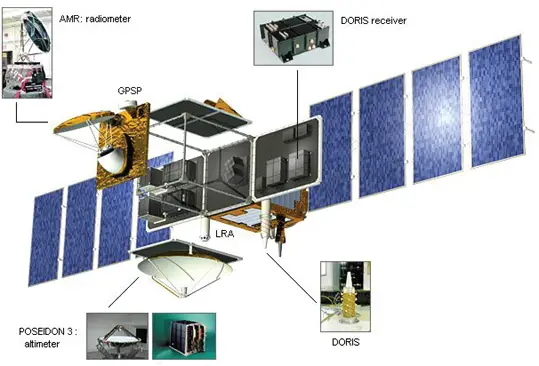
Instruments On Board the Jason 2
– CNES Poseidon-3 Altimeter is the main instrument on the Jason-2 mission. Derived from the Poseidon-1 altimeter on Topex/Poseidon and the Poseidon-2 on Jason-1, it measures sea level, wave heights and wind speed. It operates at two frequencies and is also able to estimate atmospheric electron content.
– NASA Advanced Microwave Radiometer (AMR) Three-frequency radiometer measures total water vapor along altimeter path to correct for pulse delay.
– CNES Doppler Orbitography and Radio positioning Integrated by Satellite (DORIS) Doppler tracking antenna receives ground signals for precise orbit determination, satellite tracking, and ionospheric correction data for CNES altimeter.
– NASA Global Positioning System Payload (GPSP) receiver provides precise orbit ephemeris data.
– NASA Laser Retro reflector Array (LRA) works with ground stations to track satellite and calibrate the other satellite location systems, and verify altimeter measurements.
Measuring Sea Level – Drifting Buoys
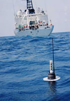 Argo floats are autonomous robotic sensors that measure properties of the ocean at various depths. Argo deployments began in 2000 and the Argo array should approach 3000 floats by the middle of 2007. These can be maintained at that level as long as national commitments provide about 800 floats per year (which has occurred for the past three years). A large battery means the floats have a useful life of about 5 years.
The Argo measurements of temperature, salinity, pressure and reference velocity (together with sea surface height from satellite altimetric data) form a dynamically complete description of the upper ocean—one which is the oceanic equivalent of today’s operational observing system for the atmosphere.
Argo is a major contributor to the WCRP’s Climate Variability and Predictability Experiment (CLIVAR) project and to the Global Ocean Data Assimilation Experiment (GODAE). The Argo array is part of the Global Climate Observing System/Global Ocean Observing System GCOS/GOOS).
Below is a video of an Argo Float being deployed from the R/V Roger Revelle during the I8S Hydrographic Survey cruise. The data from Argo floats is relayed via satellite and collected online for free use. There is also a video, Argo.avi(24.7 mb) that explains the purpose and method of Argo.