Measuring precipitation covers rain, hail, snow, rime, hoar frost and fog, and is traditionally measured using various types of rain gages such as the non-recording cylindrical container type or the recording weighing type, float type and tipping-bucket type. (See separate page for measuring snowfall .) One of the critical components of the Earth’s hydrological cycle is precipitation. Rainfall is essential for providing the fresh water that sustains life. Some say the first rain gauge was invented more than 2,000 years ago when rulers of the Choson Dynasty (now Korea) decreed that all villages were to engage in measuring precipitation. The rainfall data was then incorporated into a formula to determine the potential harvest of each farm.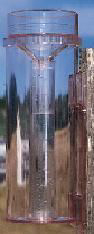 Standard Rain Gauge
Generally, standard gauges measure precipitation at or near the ground, and are observed at least once a day. The sizes of the gauges are made big enough to collect more than the average one-day or maximum 1-2 hour precipitation which differs according to various climatic conditions. The standard gauges are also commonly used to measure both rain and snow, and the latter affects fundamentally the form and dimensions of a particular national gauge (snow gauges are bigger). Thus, in countries with negligible snowfall but much rain or where different gauges are used for rain and snow (e.g., Canada), the height of the gauge orifice varies between zero and more than 1 metre above the ground.
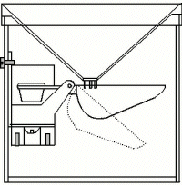 Automated Rain Gauge
There are electronic rain gauges that measures rain fall, and are also self emptying and frost proof. The basic idea is the rain collector’s measuring spoon being automatically tipped and emptied when the pre-adjusted water weight has been reached.
Small units have a funnel measurement around 5 x 10 cm, and the rain is registered with a resolution of 1 mm. The rain runs through the funnel of the rain collector into a self-emptying spoon which automatically tips and is emptied as soon as there is a certain quantity of water in the rain collector for which it has been adjusted. The spoon is fitted with a magnet kept in position by an anchor and the spoon is emptied by a quick tip – returning immediately to collecting position for collection of a new portion of water.
After one millimeter of rain, the spoon will tip and empty, and the rain fall will be shown on the device that it connected to. That can be a LCD display, data logger or a computer. The data can be transmitted over many miles or kilometres, and the measuring method is very accurate and with a maxium deviation of +/- 2%. 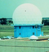 Measuring Precipitation with Weather Radar
A weather radar is a type of radar used to locate precipitation, calculate its motion, estimate its type (rain, snow, hail, etc.), and forecast its future position and intensity. Weather radars are mostly doppler radars, capable of detecting the motion of rain droplets in addition to intensity of the precipitation. Both types of data can be analyzed to determine the structure of storms and their potential to cause severe weather.
Measuring Precipitation Using Weather Satellites
A weather satellite is a type of satellite that is primarily used to monitor the weather and climate of the Earth. These meteorological satellites, however, see more than clouds and cloud systems. City lights, fires, effects of pollution, auroras, sand and dust storms, snow cover, ice mapping, boundaries of ocean currents, energy flows, etc., are other types of environmental information collected using weather satellites.
Visible-light images from weather satellites during local daylight hours are easy to interpret even by the average person; clouds, cloud systems such as fronts and tropical storms, lakes, forests, mountains, snow ice, fires, and pollution such as smoke, smog, dust and haze are readily apparent. Even wind can be determined by cloud patterns, alignments and movement from successive photos.
Many satellite services have two types of satellite images: infrared and visible. Visible images are just like those that a normal video camera (black and white) would see looking down at the earth – the brightest clouds are usually the thicker ones low down in the atmosphere and the duller clouds are the thin ones such as cirrus. Infrared (IR) images convert the temperature of the cloud, or land or sea (whichever the satellite can see at each point) to a shade of grey. The warmest points are at the ground and are black. The coolest points are high in the atmosphere (cirrus cloud) and are white. In between are shades of grey which become brighter as the cloud becomes colder (higher). The dull grey cloud which you see on the IR images is low to middle cloud. Sometimes the differences in temperature of the ground can also be seen as different shades of grey. This type of information does not show actual rainfall, rather it is inferred from the type of cloud cover.
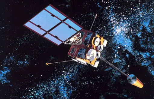
The Tropical Rainfall Measuring Mission (or TRMM) is a NASA satellite that provides more information both to test and to improve climate models. TRMM is particularly devoted to measuring precipitation in the tropics and subtropics of the earth. Among the three primary instruments on TRMM, the most innovative is the Precipitation Radar. The Precipitation Radar, built by the National Space Development Agency (NASDA) of Japan, will be the first spaceborne instrument designed to provide three-dimensional maps of storm structure. The measurements should yield invaluable information on the intensity and distribution of the rain, on the rain type, on the storm depth and on the height at which the snow melts into rain.
Below in the video you can see the orbiting fleet of NASA of satellites, a sensor web, of satellites that monitor the Earth’s natural systems. As you can see in this movie, the sensor web is in a constant state of motion, and each satellite is designed to look at a different aspect of the Earth.
 Measuring Precipitation – Disdrometer
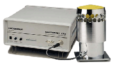
A disdrometer is an instrument used to measure the drop size distribution and velocity of falling hydrometeors. Some disdrometers can distinguish between rain, graupel, and hail. The uses for disdrometers are numerous. They can be used for traffic control, scientific examination, airport observation systems, and hydrology. The latest disdrometers employ microwave or laser technologies. 2D video disdrometers can be used to analyze individual snowflakes.
The instrument transforms the vertical momentum of an impacting drop into an electric pulse whose amplitude is a function of the drop diameter. A conventional pulse height analysis yields the size distribution of rain drops. The disdrometer for measuring precipitation consists of two units: the sensor, which is exposed to the rain and the processor for analog processing and digitizing of the sensor signal, linked by a cable to connect the two units. 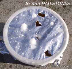 Hail Pads
Hail originates when colliding drops of water freeze together in the cold upper regions of a thunderstorm. Hail can cause considerable damage to agricultural regions, depending on the size and intensity of the hail storm. At 12:15, May 30, 1985 45 cm of hail fell in Leamington (Canada) causing damage to plants and greenhouses.
A hail pad consists of a 12″ by 12″ square of Styrofoam covered in Heavy Duty Aluminum foil. You can easily make your own hail pad.
 There are few specific instruments that measure hail. A rain gauge for measuring precipitation with a wide mouth is still in general use. However, the new Laser Precipitation Monitors (LPM) measures the amount, intensity and type of precipitation with great accuracy. The LPM is capable of measuring precipitation down to 0.16 mm diameter and can provide a drop size distribution with 400 classes. The system calculates intensity, volume (as water equivalent) and the spectrum of precipitation (diameter and velocity), the reduction to visibility in precipitation (MOR) and the radar reflectivity (Z). The LPM uses laser-optics to detect and discriminate different kinds of precipitation including:
• drizzle (DZ) • freezing drizzle (FZDZ • rain (RA) • freezing rain (FZRA) • hail (GR) • snow (SN) • snow grains (SG) • ice needles (IC) • soft hail (GS) • ice grains (PL)