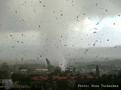
Extreme storms – On June 3rd 2010, an EF-1 water spout-turned-tornado struck the Australian coastal town of Lennox Head in northern New South Wales (image below). Unseasonably warm ocean temperatures created a pocket of warm air which collided with a cold air mass, leading to a cluster of severe thunderstorms that spawned the twister. According to a meteorologist for The Weather Channel (Australia), this was an extremely unusual event, as it occurred during austral winter and the region’s severe thunderstorm season is typically November–April. With wind speeds reaching more than 90 mph (150 km/hr), dozens of homes were damaged or destroyed.
A line of severe storms tore through the midwestern U.S. on June 5th 2010, producing several damaging tornadoes in Illinois, Indiana, Ohio, and Michigan. The largest—an EF-4 tornado with wind speeds reaching 170–175 mph (274–282 km/hr)—killed five people and caused widespread damage and destruction in the northwestern Ohio village of Millbury. This was the first EF-4 tornado to touch down in Ohio since 2002.
Extreme storms brought record rainfall and flooding and spawned severaltornadoes in Mississippi, Tennessee, Arkansas, and Kentucky in the Lower Mississippi Valley on May 1st–2nd 2010. Forty-five tornadoes touched down during this time period, according to preliminary reports by NOAA’s Storm Prediction Center. One person was killed in Arkansas by an EF-3 tornado packing winds of 145 mph (233 km/hr). Initial damage was so great officials declared a state of emergency.
On May 2nd 2010, at least 17 people were killed and 50 injured by lightning strikes as hailstorms and heavy rains pounded Bangladesh. On May 8th 2010, strong thunderstorms and torrential rains killed at least 43 people in northern India. Trees were uprooted and hundreds of homes were lost. Severe storms are common prior to the onset of the monsoon season in June.
Torrential rains accompanied by gale-force winds and a tornado swept through the southwestern Chinese municipality of Chongqing on May 5th. More than six inches (157 mm) of rain fell over a 24-hour period, according to the China News Service. At least 70 people were killed and more than 190 were injured.
A local official in Liangping county—one of the hardest-hit areas—said that this was the first time a tornado was ever reported in this region. Extreme storms continued through the month in southern China. By the end of May, an additional 45 people were reportedly killed by extreme storms and flooding. In total, the storms affected an estimated 10 million residents across 13 provinces and cities in southern China, according to the State Flood Control and Disaster Relief Headquarters website. This year’s flood season began one month earlier than normal and was attributed to the El Niño phenomenon by China’s National Meteorological Center.
Two people were killed and at least 58 others were injured as a violent weather system spawning dozens of tornadoes and baseball-size hail tore across Oklahoma and Kansas on May 10th 2010. Widespread damage and destruction caused Interstate 40—a major east-west transportation route—to close, backing up traffic for miles.
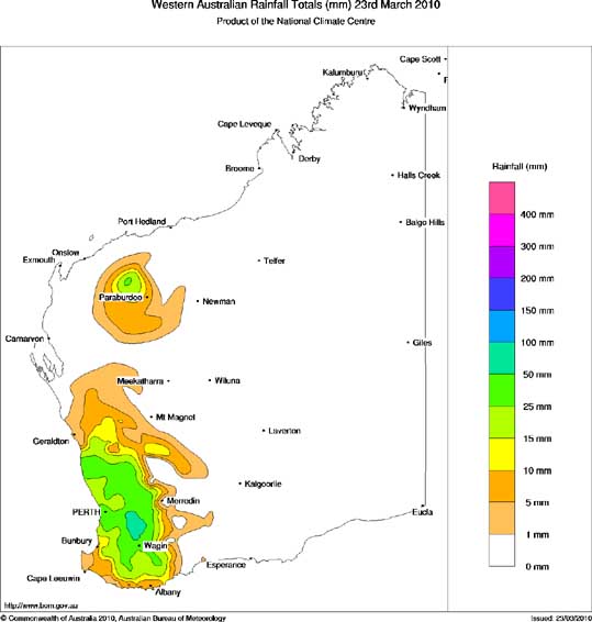
Extreme Storms – Following on the heels of its driest summer on record (December, January, and February 2010 in the Southern Hemisphere) with just 0.008 inches (0.2 mm) of measured rainfall, an extreme storm struck Perth, Australia on March 22nd 2010, bringing heavy rains, flooding, wind gusts over 75 mph (120 km/hr), and golf ball-sized hail.
According to reports, an average month’s worth of rainfall (0.6 inches or 15.6 mm) fell in just seven minutes at Perth Airport. Nearly 160,000 people lost power and damages were initially estimated to be hundreds of millions of dollars.
The strongest sandstorm of the year-to-date brought tons of sand to Beijing, China on March 20th 2010, turning the sky orange and leading officials to rate the air quality as level 5 “hazardous”—the highest ranking possible and a level rarely issued. Record pollution levels were recorded in Hong Kong, more than 1,200 miles (2,000 km) to the south; under certain conditions the sand can be transported as far away as the western U.S.
Overgrazing, deforestation, urban sprawl, and drought have all contributed to an increase in the number of sandstorms in this region. According to the Chinese Academy of Sciences, the number of sandstorms has increased sixfold in the past half century to about two dozen per year. Approximately 250,000 people were affected by this storm.
On March 24th 2010, the Harmattan—a yearly trade wind that carries dust from the Sahara Desert across West Africa—unexpectedly blew into Nigeria, coating the country with a fine layer of dust and blotting out the sun. The yellow haze from the extreme storm reduced visibility to near zero and caused flight cancellations. According to the Nigerian Meteorological Agency, the Harmattan typically ends by February.
Growing desertification due to rising temperatures is allowing the Sahara to move closer toward Nigeria. The additional dust “adds fuel” to the Harmattan winds, said a climatology professor at Osun State University. Changing patterns in the trade winds affect the timing of arrival for the rainy and dry seasons—relied upon by farmers for planting crops each year.
A tornado touched down during a severe thunderstorm in the Bahamas on March 29th 2010, killing three people and injuring at least four others. The extreme storm blew windows out of residences and hotels on Grand Bahama, uprooted trees, and tore roofs off of several buildings. Tornadoes are relatively uncommon in this region, forming approximately once every three years, according to a weather forecaster from the Bahamas Meteorology Department.
Following one of Britain’s coldest winters in several decades, heavy rain, snow, and gale-force winds pounded Scotland and Northern Ireland on March 31st, killing one person and leaving tens of thousands without power. Snow drifts up to 20 inches (50 cm) were reported.
In the Australian states of New South Wales and Queensland on the 7th February 2008, winds gusting over 90 km/hr (55 mph or 50 knots) brought down trees on houses, power lines and roads. The city of Perth, Western Australia had its wettest February since 1992 when more than 40 mm (1.6 inches) of heavy rain fell and caused a 50 day drought to end.
Severe thunderstorms, described as a one in 20 year event, affected parts of New South Wales on the 26th February 2008, producing torrential rain, golf ball size hail, and damaging winds. According to reports, flash floods were caused when as much as a months worth of rain fell in less than an hour. Across Sydney, some regions received as much as 17 mm (0.7 inches) of rain in just 15 minutes while other places had as much as 44 mm (1.7) in just 30 minutes.
In the first week of June 2007 extreme storms hit New South Wales in Australia. A natural disaster was declared across a large area of NSW after the devastating storms. High winds and flash floods damaged buildings and brought down trees, cut electricity across the Hunter, Newcastle and Central Coast and demolished roads. At least eight people died and a coal tanker ran aground on the NSW coast, with a number of other ships damaged. The cost of repairs from the storm ran into billions of dollars.

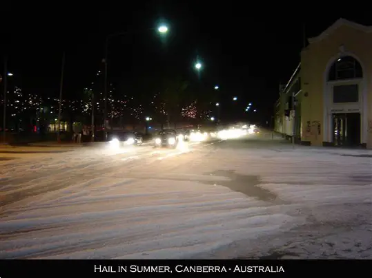
According to the the Bureau of Meteorology, a thunderstorm that struck the Australian capital city, Canberra on 27 February 2007 was a rare and highly destructive type of extreme storm.
Canberra was hit with a rare rotating storm called a super cell thunderstorm so rare that Canberra has not experienced one for at least a decade. Super cell storms are dangerous and powerful, and can cause tornadoes, winds of 200km/h, torrential rain and huge hailstones. Hailstones were created in the minus 30 degree temperatures as the storm grew to a height of 8km. When the hailstones fell to the ground in Canberra, they were up to 5cm in diameter.
A huge damages bill and disruption to the city centre were among the fallout of the storm which forced the closure yesterday of schools, government departments, the Australian National University and the city’s biggest shopping precinct. The extreme storm damage bill will run into many millions of dollars.

Info – How does a thunderstorm form?
Three basic ingredients are required for a thunderstorm to form: moisture, rising unstable air (air that keeps rising when given a nudge), and a lifting mechanism to provide the “nudge.”
The sun heats the surface of the earth, which warms the air above it. If this warm surface air is forced to rise — hills or mountains, or areas where warm/cold or wet/dry air bump together can cause rising motion — it will continue to rise as long as it weighs less and stays warmer than the air around it. As the air rises, it transfers heat from the surface of the earth to the upper levels of the atmosphere (the process of convection). The water vapor it contains begins to cool, releasing the heat, and it condenses into a cloud.
The cloud eventually grows upward into areas where the temperature is below freezing. Some of the water vapor turns to ice and some of it turns into water droplets. Both have electrical charges. Ice particles usually have positive charges, and rain droplets usually have negative charges. When the charges build up enough, they are discharged in a bolt of lightning, which causes the sound waves we hear as thunder.